India's historic and geographical contexts are very important when we look into India's border disputes with its neighbouring countries. India was under the British control for two centuries. Before Independence, British territory was divided into different Presidencies and Provinces, with independence also came India-Pakistan bifurcation. Almost all the borders were redrawn just before and after Indian independence. Despite sincere efforts British could not mediate all the boundary issues and they were passed on to Independent India.
Currently, India is part of South Asia. The northern frontiers of India are defined largely by the Himalayan mountain range, where the country borders China, Bhutan, and Nepal. Its western border with Pakistan lies in the Punjab Plain and the Thar Desert. In the far northeast, the Chin Hills and Kachin Hills, deeply forested mountainous regions, separate India from Burma. On the east, its border with Bangladesh is largely defined by the Khasi Hills and Mizo Hills, and the watershed region of the Indo-Gangetic Plain.
 |
| British Indian Empire 1909 Imperial Gazetteer of India |
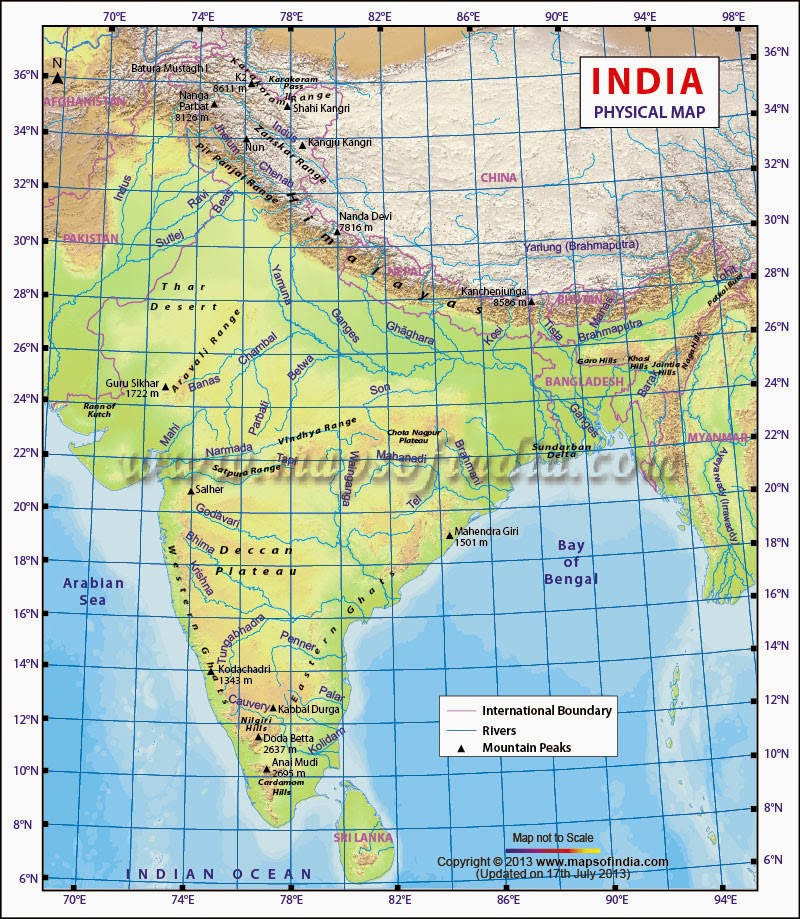 | |
| India Physical Map |
lets take up border disputes and their related issues country wise.
India & China
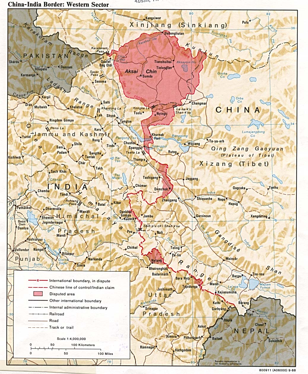 | ||
| India- China Western Border and disputed area |
The boundary issue between India and China are mainly because of two areas. One lies in the north eastern part of former princely state of Kashmir. It is now either in Indian province of Kashmir or in Xinjiang province of China. It is uninhabited wasteland crossed by Xinjiang-Tibet highway. The other boundary in dispute is between Arunachal Pradesh of India and South of Tibet.It is sparsely inhabited with numerous local tribes.
Understanding Aksai Chin dispute
Aksai Chin is North-Eastern part of Kashmir. Sikh confederacy of Punjab had annexed Ladhakh into state of Kashmir in 1934. In 1941 they invaded Tibet, Chinese forces defeated and inturn entered Ladhakh and besieged Leh. After being checked by Sikh forces Chinese and Sikh forces signed an a treaty in 1842, which stipulated no transgressions or interference in the other countries frontiers. After british victory over Sikhs, the British have attempted to meet with Chinese officials to discuss the border. However, both sides were sufficently satisfied that traditional border was recognised and defined and border was never demarcated. the boundaries at the two extremeties, Pangong Lake and karakoram pass were well defined but the Aksai Chin area lay undefined.The Johnson Line
W.H. Johnson, a civil servant with survey of India proposed the "Johnson Line" in 1865, which put Aksai Chin area in Kashmir. During this time Aksai chin was bordering Turkestan and hence Chinese were never presented this boundary line. Later Chinese reconquered Turkestan. British had doubts about this line and has been censured. In 1897 a British Military officer, Sir John Ardagh argued that this line was more defensible and later this line came to be known as "Johnson-Ardagh line".The Macartney-Macdonald Line
In 1890 British and China were allies angainst Russian threat to Aksai chin. Chinese showed interest in Aksai Chin and Britain proposed revised boundary suggested by George Macartney which put most of the Aksai Chin in Chinese territory. The British presented this line to Chinese in a note by Sir Claude Macdonald. The Chinese never ratified this and British took this as Chinese acquiescence. This line is knows as "Macartney-Macdonald line", its approximately along Line of Actual Control.Both The lines were used in British maps of India later.
Since 1947
Upon independence in 1947, the government of India used the Johnson line as the basis for official boundary in the west. The Chinese argued that the western border has never been delimited, that the Macartney-Macdonald line is the only line which was ever proposed to Chinese government. Chinese government also argues that Aksai Chin is already under the Chinese Jurisdiction, and the negotiations should take into account the status quo. During 1950s, Chinese Government built a road connecting Xinjiang and Western Tibet, which runs 179 km south of Johnson line.the Indian position, as stated by Prime Minister Jawaharlal Nehru, was that the Aksai Chin was "part of the ladhak region for centuries" and this border is "firm and definite one which was not open to discussion with anybody"
Trans Karakoram Tract
The Johnson line was not used to the west of Karakoram tract, where Pakistan-administered Gilgit-Balistan. In 1962, China and Pakistan began negotiations over boundary in the west of Karakoram pass. In 1963 they settled the boundary largely on the basis of Macartney-Macdonald line. This agreement provides renegotiation in case of settlement of Kashmir dispute. India does not recognise Pakistan and China have a common border. However, India's claim line in that area does not extend as north as Johnson line beyond karakoram tract.The McMohan Line
 |
| India-China Eastern border |
In 1914, Offical representatives from Britain, tibet and China met in Shimla and drew up an agreement regarding Tibet's borders. the Macmohan line which demarcates boundary between India and Tibet in eastern sector was drawn by Henry Macmohan on a map attached to the agreement. China immediately repudiated the agreement, objecting Sino-Tibetian boundary. A treaty was signed without consent of China, stating that China could not enjoy full rights if it does not ratify the treaty.
British wary of legal status of the accord, never put McMohan line on Maps until 1937, nor did they publish the Sila Convention in the treaty record until 1938. China argues that the Shimla Agreement is illegeal, rejecting Tibetian delcaration of Independence and stating that the agreement was between the local government of Tibet without treaty making powers and British.
Governer of Assam in 1938 declared that Tawang was undoubtedly British, which was administered by Tibet. During World War II, with the threat of Japanese invasion and Chinese expansionism, British took control of Tawang for extra defence.
China claims area south of McMohan line based on the traditional Chinese imperial boundaries and India claims the area based on British imperial boundaries. India claims that the Chinese boundaries are not recognised by any other country.
Some of the areas under indian claim lie East of McMohan line, India argues that intent of the treaty was to follow that Highest ridges of Himalayas. So, south of the highest ridges should be Indian territory and North to be Chinese territory. In Indian claim, the two armies will be divided by highest mountains in the world. In 1950s India modified McMohan line based on this and annexed Thag La, Logju and Khinzemane. India's claim moves India-China-Bhutan trijuction to 27°48'N as opposed to McMohan line's 27°44'33" N.
No comments:
Post a Comment